

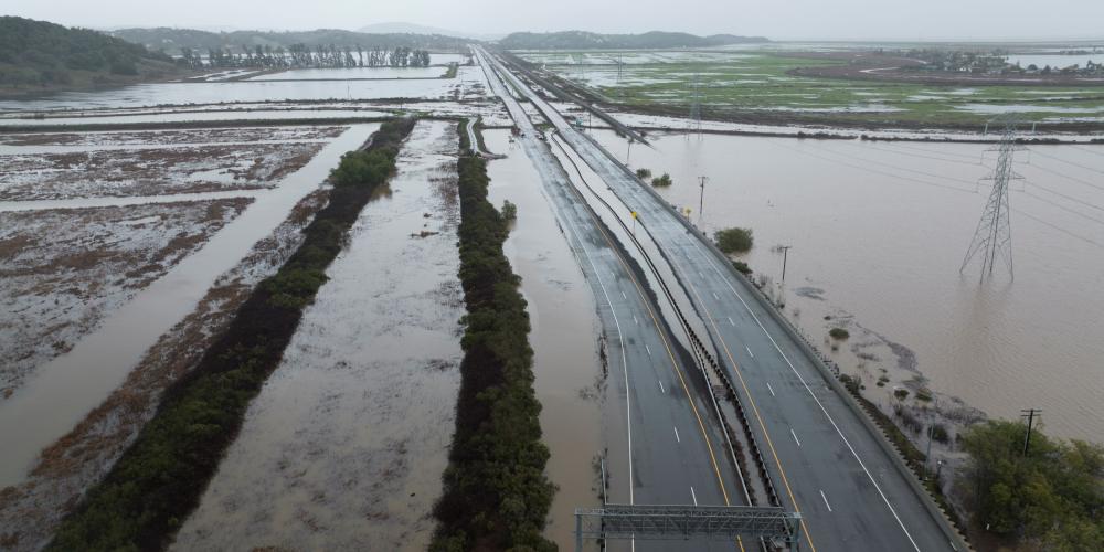
The San Francisco Estuary Partnership and partners published a study of the Novato Creek Baylands, looking at strategies to reconnect the lands to the tides, reducing upstream flood risk while restoring natural habitat.
The baylands are one of the largest remaining tidal wetland restoration opportunities in the San Francisco Bay Area. Today, thousands of acres of undeveloped diked baylands that lay along Novato Creek are disconnected from San Pablo Bay.
Rising sea levels and increasingly intense storms threaten the aging flood protection system, causing repeated flooding of State Route 37 (SR 37), noted the study, which was authored by the San Francisco Estuary Institute, San Francisco Estuary Partnership, Marin County Flood Control District, Marin Audubon Society, Environmental Science Associates, and Far Western Anthropological Research Group.
The strategy was shaped by an iterative process involving focused meetings with over a dozen regional partners, infrastructure operators, and landowners to ensure proposed restorations align with current management and future goals. This engagement process identified multiple opportunities for "win-win" solutions that can reduce flood risk and infrastructure maintenance costs while expanding baylands habitats and increasing resilience to sea level rise.
"This strategy represents an ambitious and achievable vision for restoring the Novato Baylands," said James Muller, Acting Director of the San Francisco Estuary Partnership, co-author of the study. "Its implementation will deliver lasting benefits for wildlife, habitats, communities, and infrastructure while increasing resilience to climate change."
The future Novato Creek baylands are envisioned as an expansive, connected ecosystem where mudflats and marshes transition gradually into protected uplands. The strategy is guided by three primary goals:
- Restore tidal ecosystems to the maximum extent possible, including subtidal habitats, mudflats, marshes, and adjacent upland transition zones.
- Increase the resilience of the Novato Creek baylands and upstream areas to flooding under current and future climate conditions to benefit people and wildlife.
- Build community and Tribal needs and priorities into the strategy and its restoration options.
Since the mid-1800s, diking and draining of wetlands has eliminated approximately 90% of the area’s tidal marsh, greatly reducing available habitat for species such as the California Ridgway’s rail, salt marsh harvest mouse, California black rail, and steelhead.
Diking of historical tidal marshes disconnected Novato Creek from its floodplain, reducing tidal exchange and contributing to sediment accumulation in the channel. This buildup has reduced the creek’s capacity to convey flood flows, leading to upstream flooding in the City of Novato. Sea level rise and more intense storm events are expected to further increase flood risk in the coming decades.
"The modeling conducted for this study shows the value of restoration for increasing climate resilience in the Novato area. Opening up the floodplain by restoring diked baylands would lower water levels in Novato Creek during storms, reducing flood risk in surrounding areas," said Ellen Plane, Senior Scientist of the San Francisco Estuary Institute, co-author of the study. "We look forward to continued collaboration with our partners to get these restoration projects built.”
The full Novato Creek Baylands Strategy can be read here: https://www.sfei.org/documents/novato-creek-baylands-strategy.
For more information, contact:
Alexis Gabriel (415) 778-5372 alexis.gabriel@sfestuary.org
James Muller (415)778-6674 james.muller@sfestuary.org